Reventador Volcano: Ecuador’s Most Explosive Active Volcano
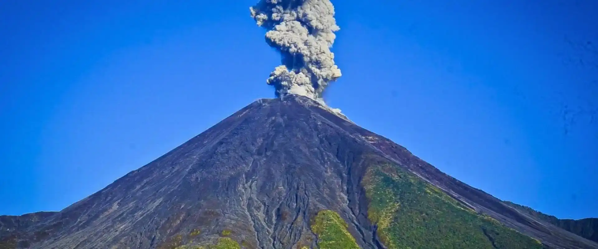
El Reventador volcano is an active andesitic stratovolcano in eastern Ecuador, located 100 km east of Quito in the Amazon-facing foothills of the Andes. Rising 3,562 meters (11,686 ft) above sea level inside Cayambe-Coca National Park, Reventador is one of Ecuador’s most continuously active volcanoes — it has erupted almost non-stop since its dramatic 2002 eruption that rained ash on Quito. Known locally as “El Reventador” (the exploder), this remote Amazon-side giant produces Strombolian to Vulcanian explosions, lava flows and pyroclastic density currents, making it a prime destination for volcano enthusiasts and Amazon adventure travelers.
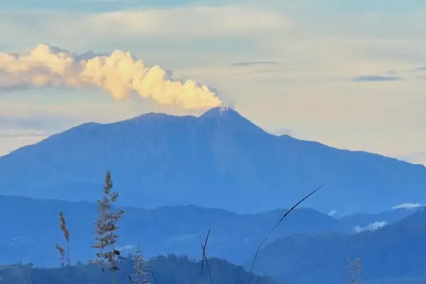
The drive to Reventador passes through the Papallacta area and drops into some of the most dramatic scenery in Ecuador — cloud forest giving way to jungle with an active volcano steaming in the background. I’ve driven this road dozens of times heading to the Oriente, and Reventador always stops me in my tracks when the clouds clear enough to show the eruption plume.
This guide covers Reventador’s volcanic activity, how to see it safely, and why this overlooked volcano deserves a spot on your Ecuador itinerary.
Pair It With the Galápagos: 9 Day Ecuador & Galápagos Tour
Reventador Volcano Current Activity (2026)
The current Reventador eruption has run almost continuously since November 2002, when a massive explosion sent an ash column 17 km into the atmosphere and dumped several centimeters of ash on Quito — the most significant ashfall the capital had experienced in modern history.
Since then, the eruption style has been mostly Strombolian with frequent lava flows, lava fountains, and pyroclastic flows confined to the caldera. The Instituto Geofísico classifies it at orange alert (elevated activity) in 2026. Eruption columns regularly reach 1-2 km above the crater.
The good news: Reventador’s eruptions are contained within the Caldera de Reventador, a large horseshoe-shaped collapse structure that channels most volcanic material to the east — away from populated areas and the main highway. The nearest town, San Rafael, sits about 8 km from the cone. Working out how many days you need? Send us your dates and we will come back with a plan.
The 2002 Eruption: When Ash Rained on Quito
On November 3, 2002, Reventador produced its largest eruption in recorded history. The Volcanic Explosivity Index (VEI) was rated 4 — the same scale as Mount St. Helens in 1980. The explosion destroyed the summit dome and created pyroclastic flows that traveled 9 km from the vent.
Quito, 90 km to the west, received 2-5 mm of ash. The airport closed. Schools shut down. People swept ash off their roofs for days. I remember waking up that morning thinking it had snowed — except the “snow” was gray and smelled like sulfur. It was the first time most Quiteños realized they lived near an active volcano that could actually affect them.
The eruption also destroyed the country’s most important oil pipeline, costing Ecuador hundreds of millions of dollars. It was a wake-up call about volcanic risk management.
How to See Reventador Volcano
The best viewpoint is from the San Rafael waterfall area (note: the original 150m San Rafael waterfall collapsed in 2020 due to erosion, but the viewpoint trail still offers excellent volcano views). Take the E45 highway from Quito toward Lago Agrio; about 3 hours east of Quito, you’ll pass through the Reventador area.
On clear days (mornings are best, before the Amazon clouds build up), you can see the volcano and any eruption activity from the highway itself. For a closer look, the old SOTE pipeline road provides access closer to the caldera rim — but check conditions with locals first, as volcanic activity can block sections.
You can also see Reventador from the Cascada de San Rafael viewpoint trail — a 30-minute hike from the highway parking area. Even without waterfall, the trail through cloud forest is beautiful, and the volcano backdrop makes it special.
Reventador’s Unique Geology
What makes Reventador unusual among Ecuador’s 84 volcanoes is its location. While most Ecuadorian volcanoes sit on the main Andean chain, Reventador is a sub-Andean volcano — positioned east of the main cordillera in the transition zone between highlands and Amazon basin. This gives it a different character: steeper, more explosive, and surrounded by jungle rather than páramo.
The current cone has been rebuilt inside the Caldera de Reventador, which formed during a massive collapse thousands of years ago. The caldera walls are 400 meters high in places, creating a natural amphitheater that contains most eruption products. This geological containment is why Reventador can erupt continuously without threatening nearby communities.
Combining Reventador With Other Destinations
Reventador sits on the main highway to Ecuador’s Amazon region (Lago Agrio, Coca, Tena). Many travelers pass right by it without stopping. Build in a half-day to explore the area. The Antisana Ecological Reserve is about an hour back toward Quito, and the Papallacta hot springs are another 30 minutes further.
A logical loop: Quito → Papallacta hot springs → Reventador volcano viewpoints → continue to the Amazon (or return to Quito). Three different ecosystems in one day.
Reventador Volcano Facts & Quick Stats
Before planning your expedition to el Reventador volcano Ecuador, here are the essential facts every traveler should know. El Reventador volcano Ecuador is one of the most remote and wildly active volcanoes in the country, sitting on the eastern edge of the Andes where mountains plunge into the Amazon basin.
- Name: El Reventador (The Exploder)
- Type: Active andesitic stratovolcano
- Elevation: 3,562 m (11,686 ft)
- Coordinates: 0.077°S, 77.656°W
- Location: Sucumbíos Province, Ecuador (Amazon slope)
- Distance from Quito: ~100 km east
- Protected area: Cayambe-Coca National Park
- Last major eruption: November 2002 (VEI 4)
- Current status: Continuously erupting since 2002
- Monitored by: Instituto Geofísico de la Escuela Politécnica Nacional (IGEPN)
START IN QUITO, END IN THE GALÁPAGOS
9 Day Ecuador and Galapagos Tour: Andes, Amazon and Santa Cruz
Quito, Cotopaxi, Quilotoa, Baños and the Amazon with your own guide, then three nights on Santa Cruz with tortoises, beaches and snorkeling.
From $1,990 per person
View itineraryWhere is Reventador Volcano Located?
The reventador volcano location is in Ecuador’s Sucumbíos Province, roughly 100 kilometers east of Quito on the Amazon-facing slope of the Eastern Cordillera. El Reventador volcano Ecuador sits inside Cayambe-Coca National Park, isolated from the main Avenue of the Volcanoes because it lies east of the Andes rather than on the central spine. The volcano rises from the cloud forest around the Quijos River valley, which dramatically amplifies its explosive character — eruptive plumes tower over dense Amazon rainforest instead of páramo grasslands.
Access is via the E45 highway (Quito–Lago Agrio road), which actually passes the volcano’s western flank. Coordinates 0.077°S, 77.656°W place Reventador just south of the equator. This remote Amazon setting is why Reventador is one of the least-visited active volcanoes in Ecuador — despite its frequent eruptions, it sees a fraction of the tourists that visit Cotopaxi or Tungurahua.
Reventador Volcano Eruption History & Current Activity (2026)
Reventador volcano eruption activity has been nearly continuous since the catastrophic 2002 event. According to IGEPN, the volcano is in an ongoing eruptive phase featuring Strombolian explosions, lava flows and occasional pyroclastic density currents. Daily seismic reports record 20–60 explosions per day and regular ash emissions reaching 500–1,500 m above the crater.
- 2002: VEI 4 eruption — largest in Ecuador in 125 years; ash fell on Quito
- 2007–2010: Lava dome growth and frequent Strombolian eruptions
- 2011–2020: Continuous eruption with lava flows down NE flank
- 2021–2025: Daily explosions, ash plumes, ballistic blocks
- 2026: Ongoing activity — orange alert for nearby communities
How to See El Reventador Volcano from Quito
Unlike Cotopaxi or Chimborazo, reventador volcano Ecuador has no developed climbing infrastructure and technical ascents are strongly discouraged due to ongoing eruptions. The best way to experience el Reventador volcano is by viewing it from the E45 highway or combining the visit with nearby waterfalls and Amazon lodges.
- Highway viewpoint (Km 90 E45): Roadside pullouts with volcano views on clear days
- San Rafael Falls area: Ecuador’s tallest waterfall was near here; scenic trail with volcano vistas
- Reserva Biológica El Reventador: Cloud forest trails for birding and volcano viewing
- Amazon lodges near Coca: Some lodges offer Reventador as an add-on
- Guided volcano-chasing tours: Specialized operators run night photography trips when activity is elevated
Combining Reventador Volcano with Amazon & Waterfall Tours
Because reventador volcano location is on the Quito–Lago Agrio road, it pairs perfectly with Amazon expeditions and the Papallacta–Baeza–Coca corridor. A typical 3–5 day itinerary combines thermal baths in Papallacta, cloud forest birding in Baeza, Reventador viewpoints along the E45, and Cuyabeno or Yasuní jungle lodges further east. This route showcases three ecosystems in a single journey — Andean páramo, eastern cloud forest and Amazon rainforest.
Travelers with limited time can do a 1-day E45 photo tour from Quito, returning the same evening. For volcano enthusiasts, we recommend pairing Reventador with Antisana (visible from Papallacta pass) and Cayambe — both are part of the same national park system and complete a comprehensive north-eastern Ecuador volcano tour.
Frequently Asked Questions
Is Reventador volcano dangerous?
The eruptions are confined to the caldera, well away from the highway and towns. You can safely observe from several kilometers away. The main risk is unexpected large explosions — extremely rare but possible. Don’t attempt to hike into the caldera. Follow Instituto Geofísico alerts.
Can you climb Reventador?
Not while it’s actively erupting — and it has been erupting since 2002. Before the current cycle, it was occasionally climbed, but access is now restricted. The caldera rim is technically reachable, but getting close to an erupting volcano is genuinely dangerous and not recommended.
How far is Reventador from Quito?
About 90 km as the crow flies, roughly 3 hours by road via the E45 highway through Papallacta. It’s on the main route to Ecuador’s Amazon region — Lago Agrio and Coca.
What happened to San Rafael waterfall near Reventador?
Ecuador’s tallest waterfall (150 meters) collapsed in February 2020. The river found an underground route, bypassing the cliff face. Scientists debate whether it was natural erosion or related to upstream hydroelectric activity. The viewpoint trail is still open and offers volcano views.
What type of volcano is Reventador?
Reventador is an active andesitic stratovolcano — a steep-sided composite cone built from alternating layers of lava flows, ash and pyroclastic material. It produces Strombolian to Vulcanian eruptions and is one of Ecuador’s most consistently active volcanoes, having erupted nearly non-stop since 2002.
Where is Reventador volcano located?
Reventador volcano is located in Sucumbíos Province, eastern Ecuador, approximately 100 km east of Quito on the Amazon-facing slope of the Andes. It sits inside Cayambe-Coca National Park at coordinates 0.077°S, 77.656°W, along the E45 highway that connects Quito to Lago Agrio.
How old is Reventador volcano?
Reventador is a relatively young volcano by geological standards — the current edifice is less than 30,000 years old, built on the remains of a much older collapsed structure. It is one of the younger active volcanoes of the Ecuadorian Andes and has been intermittently active throughout the Holocene.
When was the last eruption of Reventador?
Reventador has been in a state of continuous eruption since November 2002. As of 2026, daily Strombolian explosions, ash plumes and periodic lava flows continue to be reported by Ecuador’s Instituto Geofísico (IGEPN), making Reventador volcano eruption activity among the most persistent in South America.
What are the 7 volcanoes in Ecuador that are active?
Ecuador has several active volcanoes; the most frequently cited seven are: Cotopaxi, Tungurahua, Reventador, Sangay, Guagua Pichincha, Cayambe and Sierra Negra (Galápagos). Reventador and Sangay are the only two in nearly continuous eruption as of 2026.
Reventador: Ecuador’s Overlooked Volcanic Giant
Reventador doesn’t get the tourist attention of Cotopaxi or Chimborazo, but in terms of raw volcanic power, it’s arguably Ecuador’s most impressive. Watching lava fountains and eruption columns from a safe distance — with jungle stretching to the horizon — is an experience unique to this volcano. Check the full guide to all 84 Ecuador volcanoes for more destinations.